


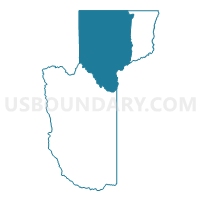
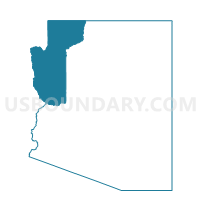
Littlefield Voting District, Mohave County, Arizona
About
Outline

Summary
| Unique Area Identifier | 525064 |
| Name | Littlefield Voting District |
| County | Mohave County |
| State | Arizona |
| Area (square miles) | 3,834.97 |
| Land Area (square miles) | 3,828.55 |
| Water Area (square miles) | 6.42 |
| % of Land Area | 99.83 |
| % of Water Area | 0.17 |
| Latitude of the Internal Point | 36.48328950 |
| Longtitude of the Internal Point | -113.56008460 |
Maps

Graphs
Select a template below for downloading or customizing gragh for Littlefield Voting District, Mohave County, Arizona


Neighbors
Neighoring Voting District (by Name) Neighboring Voting District on the Map
- Colorado City Voting District, Mohave County, AZ
- Havasupai Voting District, Coconino County, AZ
- Meadview Voting District, Mohave County, AZ
- Moccasin Voting District, Mohave County, AZ
- Outside Apple Valley #AV51.4 Voting District, Washington County, UT
- Outside Cities and Towns #OUT1 Voting District, Washington County, UT
- Outside Hurricane City #HU54.2 Voting District, Washington County, UT
- Outside Hurricane City #HU57.2 Voting District, Washington County, UT
- Outside Washington City #WA67.2 Voting District, Washington County, UT
- Peach Springs Voting District, Mohave County, AZ
- Precinct 1017, Clark County, NV
- Precinct 1516, Clark County, NV
- Precinct 1532, Clark County, NV
- Precinct 2 - Caliente, Lincoln County, NV
- Precinct 2465, Clark County, NV
- Precinct 2466, Clark County, NV
- St. George #SG27 Voting District, Washington County, UT
- St. George #SG40 Voting District, Washington County, UT
Top 10 Neighboring County Subdivision (by Population) Neighboring County Subdivision on the Map
- Clark CCD, Clark County, NV (179,324)
- St. George CCD, Washington County, UT (110,091)
- Kingman CCD, Mohave County, AZ (66,268)
- Hurricane CCD, Washington County, UT (25,701)
- North Mohave CCD, Mohave County, AZ (10,851)
- Caliente CCD, Lincoln County, NV (1,263)
- Hualapai CCD, Coconino County, AZ (6)
Top 10 Neighboring Place (by Population) Neighboring Place on the Map
- St. George city, UT (72,897)
- Mesquite city, NV (15,276)
- Colorado City town, AZ (4,821)
- Beaver Dam CDP, AZ (1,962)
- Scenic CDP, AZ (1,643)
- Littlefield CDP, AZ (308)
- Grand Canyon West CDP, AZ (2)
Top 10 Neighboring Elementary School District (by Population) Neighboring Elementary School District on the Map
Top 10 Neighboring Unified School District (by Population) Neighboring Unified School District on the Map
- Clark County School District, NV (1,951,269)
- Washington School District, UT (138,115)
- School District Not Defined, AZ (69,809)
- Kingman Unified School District, AZ (65,381)
- Colorado City Unified District, AZ (6,133)
- Lincoln County School District, NV (5,345)
- Littlefield Unified District, AZ (3,930)
- Peach Springs Unified District, AZ (1,306)
Top 10 Neighboring State Legislative District Lower Chamber (by Population) Neighboring State Legislative District Lower Chamber on the Map
- State House District 3, AZ (216,687)
- State House District 2, AZ (177,904)
- Assembly District 36, NV (59,012)
- Assembly District 20, NV (58,569)
- State House District 71, UT (51,723)
- State House District 74, UT (47,422)
- State House District 73, UT (34,070)
Top 10 Neighboring State Legislative District Upper Chamber (by Population) Neighboring State Legislative District Upper Chamber on the Map
- State Senate District 3, AZ (216,687)
- Clark County Senatorial District 12, NV (214,362)
- State Senate District 2, AZ (177,904)
- State Senate District 29, UT (120,802)
- Central Nevada Senatorial District, NV (113,138)
- Rural Nevada Senatorial District, NV (97,335)
- State Senate District 28, UT (94,905)
Top 10 Neighboring 111th Congressional District (by Population) Neighboring 111th Congressional District on the Map
- Congressional District 3, NV (1,043,855)
- Congressional District 2, AZ (972,839)
- Congressional District 2, UT (890,993)
- Congressional District 2, NV (836,562)
Top 10 Neighboring Census Tract (by Population) Neighboring Census Tract on the Map
- Census Tract 2708.01, Washington County, UT (13,516)
- Census Tract 9501, Mohave County, AZ (10,851)
- Census Tract 2709.02, Washington County, UT (10,113)
- Census Tract 2701, Washington County, UT (8,839)
- Census Tract 2703, Washington County, UT (8,148)
- Census Tract 23, Coconino County, AZ (6,674)
- Census Tract 2717.02, Washington County, UT (5,483)
- Census Tract 76, Clark County, NV (4,247)
- Census Tract 9504.02, Mohave County, AZ (3,950)
- Census Tract 2709.01, Washington County, UT (3,796)
Top 10 Neighboring 5-Digit ZIP Code Tabulation Area (by Population) Neighboring 5-Digit ZIP Code Tabulation Area on the Map
- 84790, UT (35,770)
- 89027, NV (15,275)
- 84737, UT (14,838)
- 86021, AZ (6,085)
- 86432, AZ (3,933)
- 86022, AZ (2,210)
- 86434, AZ (1,490)
- 89007, NV (1,351)
- 86444, AZ (1,289)
- 86435, AZ (487)